

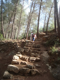
We knew that the views from The Sataf were impressive because we finished there last time. The Sataf has a number of sites that are worth mentioning. Primarily it is a series of terraces carved into the side of Mt. Eitan, with the ruins of a village that pre-dates the Israelites. These terraces were created about 4500 years ago and were used to grow subsistence crops and indigenous fruit trees. There were also more modern ruins, of the Arab village of Sataf , abandoned (expelled? depends on your political view) in 1948 and the Sataf spring whose water trickled down between the terraces in order to irrigate the crops. And thus we started today's walk, dropping down ancient steps, walking though terraces and past ruins of different styles. As we passed through these terraces we noticed that some of them have been restored and replanted in an effort to reconstruct ancient farming techniques.


After a very enjoyable half hour's walk we bottomed out, walked briefly along a path for a few minutes and then through a tunnel under road no 865. We came out of the tunnel into another world, like the children of Narnia coming through the other side of the wardrobe. The walk thus far had been in the open, past ancient ruins and agricultural terraces. The other side of the tunnel led us directly up another mountain through thick, covered natural forest with no sign of human interference other than the occasional white, blue and orange shvil marking. Civilisation was years away, only a few kilometres from the outskirts of Jerusalem.


Eventually the forest path led through more ancient terraces, but on this mountain the forest and brush had reclaimed the area through lack of use. It was a bit strange, even spooky, seeing the man-made terraces being enveloped by very natural forest. We saw a bit more of both the terraces and the forest than we planned since we missed the sign to turn right. By the time we backtracked and found the unseen marker, we'd wasted a good twenty minutes wandering around the haunted forest. This unfortunately would be a recurring theme in today's walk. Markers were often hidden or non –existent, leaving us to waste time and energy wandering around trying to find the way. To make matters worse, the two books we use proved to be even more inaccurate than usual, both in their description of the route and the maps that they provide. I can't read a map to save myself, but Yoni and Garry couldn't make any sense of the maps either and they're both proven cartographers. It proved to be a constant source of frustration in what was from all other aspects a perfect day's walk.
At this early stage we noticed for the first time other far more positive features that also recurred throughout the walk, the most obvious being the wild-flowers. I don't know enough botany to identify all the flowers blooming along the way, but the red poppies, yellow wild mustard and white, pink and mauve cyclamens were the ones I can name. Almost at every point we were surrounded by combinations of yellow, red, pink and white. The colour and flower type constantly changed, giving the feeling we were walking inside a painting


As is the case when you walk up and down mountains, the views are beautiful and multifaceted. The height, colour and angle are constantly changing, as is the view in accordance. This further enhanced our feeling of walking inside a painting. For example, we saw Moshav Even Sapir firstly from below, at the bottom of a hill. We then we circled it from 2 sides, finally passing it from above. It also frustrated the hell out of us because every where we looked we saw this bloody moshav, which led us to believe that we were merely walking around in circles and not actually progressing.The impression that we were walking in circles, which was actually the case in a number of instances, was another recurring theme of the day's walk.

I stray, just like us on the walk. Eventually we found the right path that led us through the overgrown terraces. This area has many springs and the path led us past them. If the word "springs" conjures images of picturesque pools filled with pure water, percolated up from an underground, rain-fed reservoir, inviting just you to take a dip, then your dreaming of Switzerland. This is Israel, where springs are often dirty, smelly concrete holes, half full of stagnant water, inviting dysentery to any fool-hardy enough to try their luck. I imagine that until recently, say 50 years ago, these springs really were quite enticing, tucked away in forest so close to Jerusalem. I suppose being this close to Jerusalem is the reason why that they can't stay in their pristine condition. So after the Sataf spring, we passed Uzzi, Tamar, Sarig, Amindav and Shalmon springs, amongst others whose names I don't know. Some were hidden in caves, some in stagnant pools as mentioned, others in holes in the ground and one, in a pool which almost looked inviting, but for the rowdy group of 20 kids camping there. It seems that they were a sort of organised group of rowdy kids, as there were some older rowdy adults with them, teaching them the essential lessons of being an Israeli out in nature; make noise and barbecue chicken wings on a small portable tin barbecue. I hate to think what the place looked like when they left. Close to another spring, we saw two young haredi men, walking along the path together, bright pink towels draped over their shoulders. The bright pink towels seemed a little incongruous relative to the standard black haredi outfits that they wore, leading us to theorise that perhaps they were searching for a secluded spot in order to engage in some most definitely un-haredi behaviour. We didn't investigate further, but it was more likely that the thin mountain air had simply addled our brains and imaginations.


The path takes a long, steady, if not sharp incline, which meant we walked appreciably slower than our regular fast, 4-5 k/mh pace. As we rose, we gradually approached the back of the Haddasah Ein Kerem hospital complex, until we were directly beneath it. The shvil touches the outskirts of Jerusalem here and this is as close to Jerusalem as it gets. And do either of the guide books make mention that the giant compound that we were walking towards is one of Israel's most important hospitals? Or that this is as close as we get to this insignificant little village called Jerusalem? Nah, the basis for the name of the Shalmon Spring is far more important information in a book that describes the route of Israel National Trail. Go figure.


Except for the missing or hidden markers. We always find sections where we have to stop and look for a marker, and even backtrack a hundred metres to find a marker that we don't see but is actually in plain site. Today markers were often in places that you had to search for them in illogical places or know ahead where they were, which of course makes no sense, given that we had never previously been on the route. Alternately, instead of markings every 100 metres or so, they were spaced every 200 or 300 metres and not at strategic positions. Perhaps the Shvil Elders had put Mr Shvil Painter on a tight budget, or he was pocketing the money meant to buy paint. What a scandal. I think it warrants a shvil investigation. And it happened over and over again. Garry aptly remarked that you would never imagine what joy a can of spray paint could bring to 3 middle aged men. At one particular point, at the Amindov forest perhaps, (we wouldn't know, since neither book mentions the well laid out, carefully maintained picnic spot and lookout point), we totally misplaced the markers. Yoni backtracked almost a kilometre whilst Garry and I explored different paths in different directions. And once again, the books may well have been describing nuclear physics for all the help they were in getting us where we had to get to. If you were to add up the years the three of us have known each other you get to a sum of over a hundred. It's a sign of how well we know each other when Garry asked me my opinion about which way I think we should go and promptly set off in the opposite direction. Not only did I not get the slightest bit angry, I silently congratulated him for ignoring my gut feeling and broken sense of direction. Sure enough, a kilometre down the trail, in the opposite direction to the way I would have gone, Garry found the shvil markings. We'd wasted at least half an hour not being lost, but not being found either.


Before we started the cliff-face descent we saw in the distance two lone cyclists struggling up a very steep hill. I constantly wonder where the fun is in trying to cycle up such a steep hill. I guess cyclists who see me, red faced and puffed out, struggling up some near vertical rock face, may ask themselves the same question (then again, at that particular junction in time I too might ask that same question of myself). As we strode down the path after the big drop, a worried looking man slowly drove up, asking if we'd seen his two children cycling in the area. I figured he was asking about the two lonely cyclists we'd seen from afar. You see all kinds of weird things on the shvil.
The pleasant, uneventful walking continued a bit, on a nice and easy downhill. Of course, every downhill has its uphill, and the one we were about to encounter was a real doozy. After 9km of shvil and at least another 2 trying to find the shvil, over 5 hours, we started the climb up nachal Kobi already feeling quite tired. It's only 1.5 km, but straight up. Between heart palpitations I managed to notice that it was as beautiful as anything we'd done today and if you haven't guessed, to this point its been pretty dammed pretty. We were back in natural, overgrown forest, dark and lush and green. Overcoming fears of cardiac arrest, we got to Kobi spring and found an empty picnic table becking us to place 3 cups, a thermos of herbal tea and chocolate croissants on it. Who are we to argue with empty picnic tables? In any case, no amount of chocolate croissants would replace the calories we'd just burnt.


After a nice rest we set off in order to finish the last 4 km. Of course, we lost the path or markings a few more times, cursing the day that Mr Shvil Painter got his first can of spray paint. We misplaced the markings in a Bedouin camp, where mangy dogs that looked like they hadn't eaten for a while came running up, snarling and barking, thinking dinner had finally walked in. We took a wrong turn walking across open fields and couldn't find the marking at a junction of two paths. The two authors of the guide books obviously conspired with Mr Shvil Painter, copying the descriptions of today's leg from a 1974 manual of field trips in Upper Saxony. Never-the-less, we made it back to my car, happy to see the vehicle but just as happy to have done a good, hard, challenging walk. All the major muscles and some of the minor ones in my legs were cramping in unison. Do you know what its like having your thigh, calf and hamstring arguing over which one can cause the most discomfort? I know. Certainly it was the hardest, prettiest and most varied walk we'd done for a long time. We had flowers, forests, caves, springs, ruins, steep hills and beautiful views, over a relatively compact 14 km. It took us two hours longer to cover these 14 km than it does to cover a regular, easier, 18 km. And we loved every minute of it. Almost.

No comments:
Post a Comment