Friday 29 April 2011

33rd day (Two Halves Equal a Whole)


We agree every time that it's ridiculous driving 2-3 hours before our shoes see any trail, and every time we set a new record of how much time we waste getting onto the trail, swearing that this is the last time we do it this way. Unfortunately, life constantly gets in the way of our shvil plans. So after leaving home at 5.45, dropping Yoni's daughter Lior off at her air-force base, we hit the shvil at 10 a.m. 10 a.m!!!
We occasionally crib a few hundred metres where possible, since at the end of 20 km, a 500 metre saving is very attractive. However, if cribbing 500 metres means parking your car in a location that is remote enough to allow local car thieves to practise their trade, then parking at the designated start, opposite an army base and forest study centre, seems a far better option. Much of today's walk would be through planted pine forest and the start set the tone. Unfortunately we had unwanted companions in the form of 3 very vicious dogs.
These dogs belonged to the Bedouin shepherd and part time car thief who was tending his flock not far from the path we were walking on. He was obviously angry that we'd parked in a place where he couldn't further his part time career and thus set his dogs upon us. Whilst thankfully we weren't actually bitten, having 3 large, mangy dogs barking and snarling furiously and nipping at your heels is not a great way to start the day's walk. Eventually they lost interest and this proved to be today's only drama. Even Mr. Shvil Painter was well behaved, the markings being plentiful and freshly painted. We didn't have to backtrack even once the whole day. Quite an achievement!
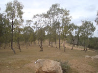
The walking was very peaceful, sometimes in the pine forest, sometimes in the open. I would have thought that even though these pine forests are planted by the J.N.F.,some effort could have been made to make it look natural. This isn't the case however. The Yatir forest consists of perfectly straight rows of planted pine, resembling Elton John's first hair transplant.  A random, more natural look would have been more convincing in both cases.


We left the forest and walked through a small nameless valley, passing a Bedouin encampment. Here in the Negev we've driven past Bedouin settlements of Hura, Rahat, Lahia and quite a few tin sheds that pass as encampments. There are Bedouin settlements in the north but it's a different feel. Perhaps it's the sandy desert, or the run-down look, but here in the Negev it's like a different Israel altogether. An Israel that resembles Soweto more than a modern western country.
We passed the Bedouin tin shed, climbed a hill past the Yatir Byzantine ruins and reached the top, where we were met by a platoon of young IDF soldiers, standing in threes, waiting for an exercise or drill to start. This is the first time in close to 500 km of shvil that we'd seen soldiers in manoeuvres. We were surprised to bump into them here, but in retrospect, it's surprising that we hadn't previously encountered other army battalions in training exercises. In any case, Yoni and Garry reminisced about their days of serving the homeland. I had little to add, my 30 days of national service and subsequent stints of guard duty in the reserves having very little affect on the annals of Israel's military history.


There were some slightly more common groups that we encountered en-route. Two groups of through shvillers, one being the "standard" two boys and a girl and another, a pair of older walkers. We don't see many walkers older than us on the shvil and if we do, never through shvillers with their entire earthly belongings strapped to their backs. One was short and wizened, the other tall, thin and rangy. A sort of septuagenarian Tortoise and the Hare. Garry warned that if we didn't get a move on, we'd look like that by the time we reach Eilat. And I don't think he meant it in a positive way. Other common shvill sights included a large group of moto-cross riders, kicking up a dust storm as they drove past. A large group of very serious 4*4 off roaders were having morning tea in a valley we passed through. These vehicles weren't your average soft-road AWD's that might get get you through a  mud patch. They all had winches on the front, all sorts of equipment that would help them circumnavigate the moon and looked as if they were preparing to cross the Kalahari. If I was to buy an off road vehicle, it would be one of these heavy-duty ones. Even though I prefer to walk the outdoors, not drive it, doing some real, hard, off-road stuff would be fun.


As we passed trig point 492 and climbed yet another hill, we saw below us a high wire-mesh fence.  Between the fence and the adjacent road was a broad sand strip. It looked like a border between enemy states, lets say between Israel and Lebanon, or perhaps an area meant to keep foreigners out, between the US.A and Mexico, for example. It was indeed a border, between Israel proper and the occupied West Bank. It didn't resemble in any way the border of 2 municipalities within Israel, rather It gave the impression that you were about to go into a different country altogether. Hard to see the logic that both sides of a fence like that are part of one country.


We started the day at 650 metres above sea level and walked for a fair bit of time going up and down hills more or less at that height. The last few walks in this area leading to this point have been through semi-desert, green with abundant winter rain. As we head further east and south and the season moves from winter to spring, the green gives way to the dry desert yellow. From this height, looking down to the area below, we saw this transformation quite clearly and it reminded us that from here on in this is what we're going to be walking through. At 650 metres, the weather was quite cool and pleasant. Later in the day we would walk at an altitude of close to 900 metres where the feeling was almost alpine. As we dropped down and approached Meitar at just below 400 metres, the temperature was noticeably higher, the air felt a lot heavier and alpine had given way to desert .
As we walked past Meitar we spotted a family flying model planes.Their dog was keeping them company. As we walked past, the dog gave 2 short barks and sniffed us, tail wagging in welcome. Somehow the comparison with the pack of wolves at the beginning reminded us the differences of cultures in such a small area and how we and our friendly little dogs really don't stand a chance in the rough and tumble reality of the middle-east.

Even though we'd started late and a net drop of 250 metres entailed lots of ups and downs, when we reached Meitar we weren't too tired and had made good time in covering 14 km. With the desire to make the most of the fact that in order to walk in this area we have to drive a long way, we decided to go back to the very start of this leg, at Mt. Amasah and walk through to the forest centre where we'd started. In other words, we started the day in the middle of the leg and walked to the end, then double backed to the actual start of the leg and walked to our starting point, which is actually the middle. Confused? That's nothing compared to the absolute bewilderment on the faces of the 2 groups of through shvillers that we'd seen in the first half, as we crossed paths with them a second time. They couldn't understand how you could cross paths with the same walkers twice in one day. They sheepishly looked over their shoulders, being sure it was a "candid camera" stunt. Not to worry. We may have walked the second half first, but in the end we completed the full 22 km route (with a little bit of obligatory cribbing).


 Tuval, where my home is, may not exactly be the centre of the universe, but compared to kibbutz Mt Amasah, it's positively New York City. Mt Amasah is at the end of a road, quite literally, in the middle of no-where,  that you climb for what seems forever , winding through backlands that looks like they get only one visitor every three weeks. At almost 900 metres above sea level, this area in no way resembles the desert below. The only thing that reminded us that we were in fact in close to the desert was the large herd of camels grazing happily on the top of the mountain. We're always looking for an alternative method of progressing along the shvil. Perhaps next time we'll ride the shvil on camel. Who knows?

This part of the walk was not substantially different from what we'd seen earlier; ups and downs, through and around pine forests. We did so much walking through pine forest today that upon arriving home, rather than the usual complaints that I'm all sweaty and smelly, Susan and Sivan both commented that I smelt really good, of the fresh outdoors, meaning of pine forest (or they thought that I'd sprayed myself with pine scented air freshener in the bathroom in order to mask the odour of stale sweat).

 Our next walk is from Mt. Amasah  to the town of Arad. Arad itself holds no particular interest, but  after Arad we get onto the last 400 km of hard walking through real desert. We spoke about it along the way, voicing our fears of getting into the most difficult parts of the shvil. We pretty much agreed that we're going to have to lose weight,and get fit in order to complete the remainder of the shvil. It will also take a lot of logistic manoeuvring, resolve and mental toughness.
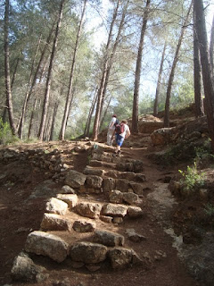
A couple of hours after setting off from Mt. Amasah we got to Yoni's car. Most of this part had been downhill, but for the final 300 metres that had us climb a steep hill in order to arrive to the entrance to the forest research centre. This final climb was as if to remind us that even if we drop 250 metres in altitude, the shvil is still going to serve us up some uphills.
We'd started  later than usual and had walked a long way, so we were eager to head back. We'd gotten three quarters of the way home when the need to replenish protein hit us. Just as well that the El-Sultan restaurant in Zarzir serves good hummus and shawarma.

Monday 18 April 2011

32nd day (Almost Perfect)


There was some doubt as to whether we were actually going to get on to the shvil today. I sprained my ankle a couple of months ago and it had been giving me some trouble during the week. I even asked my doctor what she thought and she was quite adamant that 14 km up and down mountains in the Jerusalem Hills was not a recommended cure for swollen ankles. I nodded my head in agreement, took note of her advice and walked anyway. And what a beautiful walk it was.
We knew that the views from The Sataf were impressive because we finished there last time.  The Sataf has a number of sites that are worth mentioning. Primarily it is a series of terraces carved into the side of Mt. Eitan, with the ruins of a village that pre-dates the Israelites. These terraces were created about 4500 years ago and were used to grow subsistence crops and indigenous fruit trees. There were also more modern ruins, of the Arab village of Sataf , abandoned (expelled? depends on your political view) in 1948 and the Sataf spring whose water trickled down between the terraces in order to irrigate the crops. And thus we started today's walk, dropping down ancient steps, walking though terraces and past ruins of different styles. As we passed through these terraces we noticed that some of them have been restored and replanted in an effort to reconstruct ancient farming techniques.


After a very enjoyable half hour's walk we bottomed out, walked briefly along a path for a few minutes and then through a tunnel under road no 865. We came out of the tunnel into another world, like the children of Narnia coming through the other side of the wardrobe. The walk thus far had been in the open, past ancient ruins and agricultural terraces. The other side of the tunnel led us directly up another mountain through thick, covered natural forest with no sign of human interference other than the occasional white, blue and orange shvil marking. Civilisation was years away, only a few kilometres from the outskirts of Jerusalem.


Eventually the forest path led through more ancient terraces, but on this mountain the forest and brush had reclaimed the area through lack of use. It was a bit strange, even spooky, seeing the man-made terraces being enveloped by  very natural forest. We saw a bit more of both the terraces and the forest than we planned since we missed the sign to turn right. By the time we backtracked and found the unseen marker, we'd wasted a good twenty minutes wandering around the haunted forest. This unfortunately would be a recurring theme in today's walk. Markers were often hidden or non –existent, leaving us to waste time and energy wandering around trying to find the way. To make matters worse, the two books we use proved to be even more inaccurate than usual, both in their description of the route and the maps that they provide. I can't read a map to save myself, but Yoni and Garry couldn't make any sense of the maps either and they're both proven cartographers. It proved to be a constant source of frustration in what was from all other aspects a perfect day's walk.
At this early stage we noticed for the first time other far more positive features that also recurred throughout the walk, the most obvious being the wild-flowers. I don't know enough botany to identify all the flowers blooming along the way, but the red poppies, yellow wild mustard and white, pink and mauve cyclamens were the ones I can name.  Almost at every point we were surrounded by combinations of yellow, red, pink and white. The colour and flower type constantly changed, giving the feeling we were walking inside a painting

.

As is the case when you walk up and down mountains, the views are beautiful and multifaceted. The height, colour and angle are constantly changing, as is the view in accordance. This further enhanced our feeling of walking inside a painting. For example, we saw Moshav Even Sapir firstly from below, at the bottom of a hill. We then we circled it from 2 sides, finally passing it from above. It also frustrated the hell out of us because every where we looked we saw this bloody moshav, which led us to believe that we were merely walking around in circles and not actually progressing.The impression that we were walking in circles, which was actually the case in a number of instances, was another recurring theme of the day's walk.

I stray, just like us on the walk. Eventually we found the right path that led us through the overgrown terraces. This area has many springs and the path led us past them. If the word "springs" conjures  images of picturesque pools filled with pure water, percolated up from an underground, rain-fed reservoir, inviting just you to take a dip, then your dreaming of Switzerland. This is Israel, where springs are often dirty, smelly concrete holes, half full of stagnant water, inviting dysentery to any fool-hardy enough to try their luck. I imagine that until recently, say 50 years ago, these springs really were quite enticing, tucked away in forest so close to Jerusalem. I suppose  being this close to Jerusalem is the reason why that they can't stay in their pristine condition. So after the Sataf spring, we passed Uzzi, Tamar, Sarig, Amindav and Shalmon springs, amongst others whose names I don't know. Some were hidden in caves, some in stagnant pools as mentioned, others in holes in the ground and one, in a pool which almost looked inviting, but for the rowdy group of 20 kids camping there. It seems that they were a sort of organised group of rowdy kids, as there were some older rowdy adults with them, teaching them the essential lessons of being an Israeli out in nature; make noise and barbecue chicken wings on a small portable tin barbecue. I hate to think what the place looked like when they left. Close to another spring, we saw two young haredi  men, walking along the path together, bright pink towels draped over their shoulders. The bright pink towels seemed a little incongruous relative to the standard black haredi outfits that they wore, leading us to theorise that perhaps they were searching for a secluded spot in order to engage in some most definitely un-haredi behaviour. We didn't investigate further, but it was more likely that the thin mountain air had simply addled our brains and imaginations.


The path takes a long, steady, if not sharp incline, which meant we walked appreciably slower than our regular fast, 4-5 k/mh pace. As we rose, we gradually approached the back of the Haddasah Ein Kerem hospital complex, until we were directly beneath it. The shvil touches the outskirts of Jerusalem here and this is as close to Jerusalem as it gets. And do either of the guide books make mention that the giant compound that we were walking towards is one of Israel's most important hospitals? Or that this is as close as we get to this insignificant little village called Jerusalem? Nah, the basis for the name of the Shalmon Spring is far more important information in a book that describes the route of Israel National Trail. Go figure.

 As the Hadassah Ein Kerem hospital complex loomed large ahead of us, the forest changed from planted pine to burnt pine. A fire had obviously burnt the area quite recently as very little vegetation had grown back over the winter and walking through was spooky in an altogether different way to the forest that reclaimed the ancient terraces. The burnt out area was not large and we continued through the pine forest, climbing ancient stairs or terraces, passing springs or ruins along the way. With perfect weather and being amongst the spring flowers , not for the first time, we muttered in agreement, "it doesn't get any better than this".


Except for the missing or hidden markers. We always find sections where we have to stop and look for a marker, and even backtrack a hundred metres to find a marker that we don't see but is actually in plain site. Today markers were often in places that you had to search for them in illogical places or know ahead where they were, which of course makes no sense, given that we had never previously been on the route. Alternately, instead of markings every 100 metres or so, they were spaced every 200 or 300 metres and not at strategic positions. Perhaps the Shvil Elders had put Mr Shvil Painter on a tight budget, or he was pocketing the money meant to buy paint. What a scandal. I think it warrants a shvil investigation. And it happened over and over again. Garry aptly remarked that you would never imagine what joy a can of spray paint could bring to 3 middle aged men. At one particular point, at the Amindov forest perhaps, (we wouldn't know, since neither book mentions the well laid out, carefully maintained picnic spot and lookout point), we totally misplaced the markers. Yoni backtracked almost a kilometre whilst Garry and I explored different paths in different directions. And once again, the books may well have been describing nuclear physics for all the help they were in getting us where we had to get to. If you were to add up the years the three of us have known each other you get to a sum of over a hundred. It's a sign of how well we know each other when Garry asked me my opinion about which way I think we should go and promptly set off in the opposite direction. Not only did I not get the slightest bit angry, I silently congratulated him for ignoring my gut feeling and broken sense of direction. Sure enough, a kilometre down the trail, in the opposite direction to the way I would have gone, Garry found the shvil markings. We'd wasted at least half an hour not being lost, but not being found either.

When we saw what lay ahead,  we had second thoughts about finding the right path. Directly beneath us, about 300 metres down, was a wide dirt track. In order to get there the shvil had us drop down a near vertical "path", sliding down on our bums over hard rock as much as walking, one foot after the other. I quite enjoy these steep downhills, despite the risk to an already problematic ankle. Yoni has some eye-foot co-ordination issues and finds these vertical drops quite scary. Garry is an old mountain goat that chugs along no matter the terrain. We arrived to the bottom safe and sound, glad to walk for a while on an easy, wide, well marked trail. To this point we'd been on the trail for at least 4 hours and had covered perhaps 8 kilometres, including unwanted stops and backtracking. We still had a long way to go. It was frustrating to Yoni to have useless guide books and maps. He couldn't get a grip on where we were, where we had to go next and approximately how long more we'd be on the trail. I also like to have some sort of sense of where we are, but since it was obvious that we were on our own on this one, took it as a fact and relaxed. Garry has his no-nonsense mountain goat attitude, continuing on, one step at a time.

Before we started the cliff-face descent we saw in the distance two lone cyclists struggling up a very steep hill. I constantly wonder where the fun is in trying to cycle up such a steep hill. I guess cyclists who see me, red faced and puffed out, struggling up some near vertical rock face, may ask themselves the same question (then again, at that particular junction in time I too might ask that same question of myself). As we strode down the path after the big drop, a worried looking man slowly drove up, asking if we'd seen his two children cycling in the area. I figured he was asking about the two lonely cyclists we'd seen from afar. You see all kinds of weird things on the shvil.
The pleasant, uneventful walking continued a bit, on a nice and easy downhill. Of course, every downhill has its uphill, and the one we were about to encounter was a real doozy. After 9km of shvil and at least another 2 trying to find the shvil, over 5 hours, we started the climb up nachal Kobi already feeling quite tired. It's only 1.5 km, but straight up. Between heart palpitations I managed to notice that it was as beautiful as anything we'd done today and if you haven't guessed, to this point its been pretty dammed pretty. We were back in natural, overgrown forest, dark and lush and green. Overcoming fears of cardiac arrest, we  got to Kobi spring and found an empty picnic table becking us to place 3 cups, a thermos of herbal tea and chocolate croissants on it. Who are we to argue with empty picnic tables? In any case, no amount of chocolate croissants would replace the calories we'd just burnt.


After a nice rest we set off in order to finish the last 4 km. Of course, we lost the path or markings a few more times, cursing the day that Mr Shvil Painter got his first can of spray paint. We misplaced the markings in a Bedouin camp, where mangy dogs that looked like they hadn't eaten for a while came running up, snarling and barking, thinking dinner had finally walked in. We took a wrong turn walking across open fields and couldn't find the marking at a junction of two paths. The two authors of the guide books obviously conspired with Mr Shvil Painter, copying the descriptions of today's leg from a 1974 manual of field trips in Upper Saxony. Never-the-less, we made it back to my car, happy to see the vehicle but just as happy to have done a good, hard, challenging walk. All the major muscles and some of the minor ones in my legs were cramping in unison. Do you know what its like having your thigh, calf and hamstring arguing over which one can cause the most discomfort? I know. Certainly it was the hardest, prettiest and most varied walk we'd done for a long time. We had flowers, forests, caves, springs, ruins, steep hills and beautiful views, over a relatively compact 14 km. It took us two hours longer to cover these 14 km than it does to cover a regular, easier, 18 km. And we loved every minute of it. Almost.
Outdoors Blogs
Outdoors blogs